
With each pass, the scientists aboard these planes take measurements that satellites can’t and send them to forecasters at the National Hurricane Center. — The Conversation
. We might start to see the ingredients quickly coming together: Is the ocean warm to a great depth? Is the atmosphere nice and juicy, with a lot of moisture around the storm? Are the winds favorable? We also look at the inner core: What does the structure of the storm look like, and is it starting to consolidate?
Satellites can offer forecasters a basic view, but we need to get our hurricane hunters into the storm itself to really pick the hurricane apart.Hurricanes like to stand up straight – think of a spinning top. So, one thing we look for is alignment. A storm that isn’t yet fully together might have low-level circulation, a few kilometers above the ocean, that isn’t lined up with its mid-level circulation 6 or 7 kilometers up. That isn’t a very healthy storm. But a few hours later, we might fly back into the storm and notice that the two centers are more lined up. That’s a sign that it could rapidly intensify., the area just above the ocean.
So we might watch our dropsonde or tail doppler radar data for how the winds are flowing at the boundary layer. Is that really moist air rushing in toward the center of the storm? If the boundary layer is deep, the storm can also take a bigger inhale.We also look at the structure. A lot of times the storm looks healthy on satellite, but we’ll get in with the radar and the structure is sloppy or the eye may be filled with clouds, which tells us the storm isn’t quite ready to rapidly intensify.
Air in, up and out – the breathing – is a great way to diagnose a storm. If that breathing looks healthy, it can be a good sign of an intensifying storm.We need instruments that not only measure the atmosphere but also the ocean. The winds can steer a storm or tear it apart, but the ocean heat and moisture are its fuel.to measure temperature, humidity, pressure and wind speed, and send back data every 15 feet or so all the way to the ocean surface.
Singapore Latest News, Singapore Headlines
Similar News:You can also read news stories similar to this one that we have collected from other news sources.
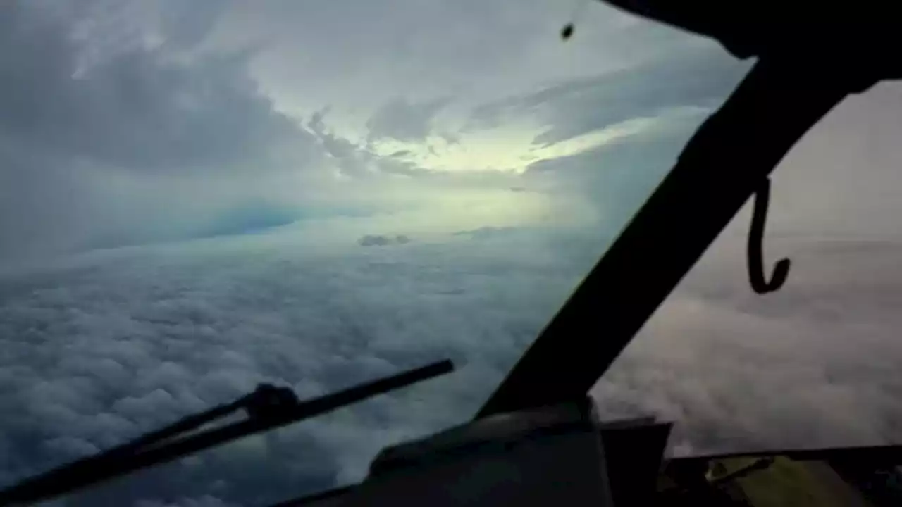 Hurricane hunters flying in Ian's strong winds: Here's what happens when plane is in storm's eyeScientists on planes flying through Hurricane Ian's center are taking measurements satellites can’t and sending them to hurricane forecasters.
Read more »
 Tropical Storm Ian's uncertain path has all of Florida preparing for a major hurricaneIts exact path still uncertain, Tropical Storm Ian strengthened Sunday night as it churned in the Caribbean, threatening to arrive in Florida as a hurricane packing powerful winds and dangerous storm surge.
Read more »
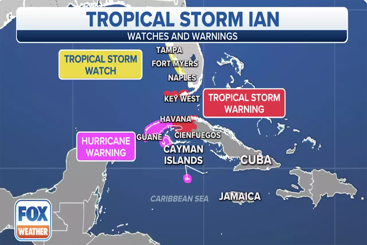 Tropical Storm Ian forecast to rapidly intensify into hurricane, significant threat eyes FloridaThe National Hurricane Center issued a Tropical Storm Warning for the lower Florida Keys as Tropical Storm Ian moves closer to the U.S. It is forecast to become a hurricane Monday.
Read more »
 Hurricane Ian forms in Caribbean, prompting Hurricane Watch for Florida's Gulf Coast, including Tampa BayA Hurricane Watch has been issued along Florida's Gulf Coast ahead of the expected wind, rain, and storm surge from Hurricane Ian later this week.
Read more »
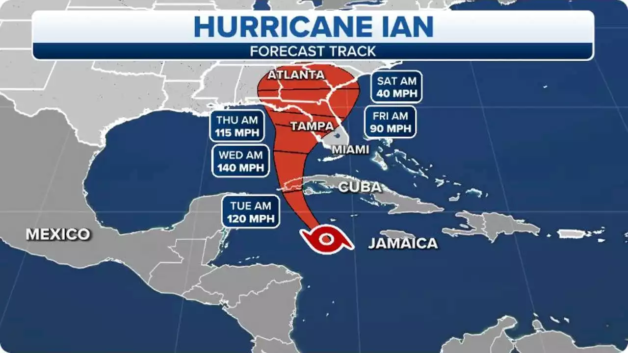
 Hurricane Ian strikes Cuba, strengthens to Category 3 as it targets FloridaHurricane Ian strengthened to a major hurricane Tuesday and has reached maximum sustained winds of 125 mph. The storm made landfall in Cuba and is now a Category 3.
Read more »
 Hurricane Ian now a Category 3 storm, bringing storm surges to Florida’s west coastHurricane Ian’s sustained winds intensified to around 125 mph early Tuesday morning as the storm strengthened to a Category 3 hurricane, making landfall in western Cuba.
Read more »